User-agent: Mediapartners-Google Allow: / User-agent: Adsbot-Google Allow: /

Saturday, July 30, 2016

Sinai Major Cities and Towns


El-Arish
Dahab
Noweiba
Rafah
Sharm el-Sheikh
Ras As-Sudr
Taba
El-Tor (Tur Sinai)

About the Area

After 8,000 years at the heart of history, experience the continuing contrasts. Sinai is where rock meets coral reef and the desert stops at the sea. It is the grandeur of granite meeting golden beaches. Here, you will find tropical fish and rare birds, spectacular sunsets and clear starry nights.Meet Sinai and discover yourself.

El-Arish has shady palm beaches, Mediterranean waves and the glowing colors of Bedouin crafts. Sharm el-Sheikh is the simplicity of sun, sea and sand. The luxury of five-star hotels, water sports, shopping and entertainment. Ras Mohamed is a world famous paradise of coral gardens and tropical fish.

"Forget not that the earth delights to feel your bare feet and the winds long to play with your hair". - Khalil Gibran.
Sinai is the land of discovery. It is the route to the Promised Land, where Isis sought Osiris and the Pharaohs found gold. It is where Moses witnessed the Burning Bush and the Bedouins camped by Crusader forts. Sinai is the meeting point for three great religions, at the crossroads of Africa and Asia.

How To Get to Sinai

From outside Egypt
Many international flights now go direct to Sharm el-Sheikh, contact us for details.

From Cairo

Friday, July 29, 2016

Sharm el-Sheikh

Sharm el-Sheikh is on a promontory overlooking the Straits of Tiran at the mouth of the Gulf of Aqaba. Its strategic importance led to its transformation from a fishing village into a major port and naval base for the Egyptian Navy. It was captured by Israel during the Suez Crisis of 1956 and restored to Egypt in 1957. A United Nations peacekeeping force was subsequently stationed there until the 1967 Six-Day War when it was recaptured by Israel. Sharm el-Sheikh remained under Israeli control until the Sinai peninsula was restored again to Egypt in 1982 after the Israel-Egypt Peace Treaty of 1979.[citation needed]
A hierarchical planning approach was adopted for the Gulf of Aqaba, whereby their components were evaluated and subdivided into zones, cities and centers. In accordance with this approach the Gulf of Aqaba zone was subdivided into four cities: Taba, Nuweiba, Dahab and Sharm El-Sheikh. Sharm el-Sheikh city has been subdivided into five homogeneous centers, namely Nabq, Ras Nusrani, Naama Bay, Umm Sid and Sharm El Maya.

A street in Naama Bay.
Sharm el-Sheikh city together with Naama Bay, Hay el Nour, Hadaba, Rowaysat, Montazah and Shark's Bay form a metropolitan area.
Before 1967 Sharm el-Sheikh was little more than an occasional base of operations for local fishermen; the nearest permanent settlement was in Nabk, north of Ras el-Nasrani ("The Tiran Straits"). Commercial development of the area began during the Israeli presence in the area. The Israelis built the town of Ofira, overlooking Sharm el-Maya Bay and the Nesima area, and opened the first tourist-oriented establishments in the area 6 km north at Naama Bay. These included a marina hotel on the southern side of the bay, a nature field school on the northern side, diving clubs, a now well-known promenade, and the Naama Bay Hotel.[citation needed]
After Sinai was restored to Egypt in 1982 the Egyptian government embarked on an initiative to encourage continued development of the city. Foreign investors – some of whom had discovered the potential of the locality during the Israeli occupation – contributed to a spate of building projects. Environmental zoning laws currently limit the height of buildings in Sharm el-Sheikh so as to avoid obscuring the natural beauty of the surroundings.
In 2005, the resort was hit by the Sharm el-Sheikh terrorist attacks, which were perpetrated by an extremist Islamist organisation, and aimed at Egypt's tourist industry. Eighty-eight people were killed, the majority of them Egyptians, and over 200 were wounded by the attack, making it the deadliest terrorist action in the country's history (exceeding the Luxor massacre of 1997).[1]
The city has played host to a number of important Middle Eastern peace conferences, including the 4 September 1999 agreement to restore Palestinian self-rule over the Gaza Strip. A second summit was held at Sharm on 17 October 2000 following the outbreak of the second Palestinian intifada, but it failed to end the violence. A summit was held in the city on 3 August 2005 on developments in the Arab world such as the situation in Iraq and the Arab-Israeli conflict. The World Economic Forum on the Middle East 2008 was also hosted by Sharm el-Sheikh.[2]
Amidst the 2011 Egyptian protests, President Hosni Mubarak reportedly went to Sharm el-Sheikh and resigned there on 11 February 2011.[3]


The average temperatures during the winter months (November to March) range from 15 to 35 degrees Celsius (59-95°F) and during the summer months (April to October) from 20 to 45 degrees Celsius (68-113°F). The temperature of the Red Sea in this region ranges from 21 to 28 degrees Celsius (70-84°F) over the course of the year


Thursday, July 28, 2016

Memphis, A Special Edition

The Name we use today derives from the Pyramid of Pepy I at Saqqara, which is Mennufer (the good place), or Coptic Menfe. Memphis is the Greek translation. But the City was originally Ineb-Hedj, meaning "The White Wall". Some sources indicate that other versions of the name may have even translated to our modern name for the country, Egypt. During the Middle Kingdom, it was Ankh-Tawy, or "That Which Binds the Two Lands". In fact, its location lies approximately between Upper and Lower Egypt, and the importance of the area is demonstrated by its persistent tendency to be the Capital of Egypt, as Cairo just to the North is today.
Statuary on the grounds of the small area we now call Memphis

Memphis, founded around 3,100 BC, is the legendary city of Menes, the King who united Upper and Lower Egypt. Early on, Memphis was more likely a fortress from which Menes controlled the land and water routes between Upper Egypt and the Delta.  Having probably originated in Upper Egypt, from Memphis he could control the conquered people of Lower Egypt. However, by the Third Dynasty, the building at Saqqara suggests that Memphis had become a sizable city.

Tradition tells us that Menes founded the city by creating dikes to protect the area from Nile floods. Afterwards, this great city of the Old Kingdom became the administrative and religious center of Egypt. In fact, so dominating is the city during this era that we refer to it as the Memphite period.  It became a cosmopolitan community and was probably one of the largest and most important cities in the ancient world. When Herodotus visited the city in the 5th century BC, a period when Persians ruled Egypt, he found many Greeks, Jews, Phoenicians and Libyans amoung the population.
Entrance to the small museum which houses the Ramses Colossus

Frankly, our concept of Memphis today is very artificial. The city must have been huge, judging from the size of its necropolises which extend for some 19 miles along the west bank of the Nile. These include Dahshure, Saqqara, Abusir, Zawyet el-Aryan, Giza and Abu Rawash, who's names derive not from their origins, but from modern nearby communities. Very few people can imagine the age of this city, as no European cities have yet to attain the span of Memphis' existence, and it is completely outside the comprehension of people in the Americas. Rome may eventually outlast Memphis, but as with any city that remains active for thousands of years, the city center, and various areas of the city shifted over the years, so today, what we think of as Memphis is rather artificial. Some scholars believe that the city may have shifted first north, and then back south though its three millennium history.


A tourist gets her picture taken in front of the Alabaster Sphinx.

But there is little left of the City today, at least that can be seen. Originally, the city had many fine temples, palaces and gardens. But today, other than the scattered ruins, most of the city is gone, or lies beneath cultivated fields, Nile silt and local villages. What we do know of Memphis comes to us from its necropolises, mentioned above, text and papyrus from other parts of Egypt and Herodotus, who visited the city.

For example, we have a number of papyruses from the time of the mysterious Akhenaten  concerning Memphis on such mundane matters as bread baking. And we know that the royal decree rejecting the Cult of Akhenaten issued by Tutankhamun after the earlier king's death originated in Memphis, indicating the cities importance, even over Thebes, in the New Kingdom.


What happened to the city to cause its complete demise is somewhat unclear. In later Dynasties Thebes became the capital of Egypt, but we know that Memphis retained much of its religious significance and continued to prosper during this period. Actually, Thebes was never exactly the administrative center of Egypt which Memphis was, its significance being more religious. In fact, by the 18th Dynasty, the Egyptian Kings had apparently moved back into the Palaces of Memphis. But when the Greeks arrived, and moved the Egyptian capital to Alexandria, Memphis suffered, and with the entrance of Christianity and the decline of Egyptian religion, Memphis became a mere shadow of the former great city. But the actual demise of Memphis probably occurred with the invasion of the Muslim conquerors in 641 when they established their new capital not at Memphis, but a short distance north of the city at Fustat, which is now a part of Cairo called Old Cairo, or Coptic Cairo.

Still, in the 12th Century AD, one traveler wrote, "the ruins still offer, to those who contemplate them, a collection of such marvelous beauty that the intelligence is confounded, and the most eloquent man would be unable to describe them adequately".  But during the Mameluke period of Egypt, the dikes which held back the Nile floods fell into disrepair, after which Memphis was apparently and slowly covered in silt.

The Colossus of Ramses


Wednesday, July 27, 2016

The Suez Canal


There seems to have always been an interest in linking the Mediterranean and Red Sea. Most of the early efforts were directed towards a link from the Nile to the Red Sea, thus indirectly linking the Red Sea to the Mediterranean through the Nile.  Strabo and Pliny record that the earliest effort was directed by Senusret III, but no evidence that there was an actual canal built exists.  The earliest efforts may have actually occurred at the command of Seti I or Ramesses II during the 13th century BC.

According to the Chronicle of the Pharaohs by Peter A. Clayton, under Necho II (610-595 BC) a canal was built between the Pelusian branch of the Nile and the northern end of the Bitter Lakes (which lies between the two seas)  at a cost of, reportedly, 100,000 lives.  However, over many years, the canal fell into disrepair, only to be extended, abandoned, and rebuilt again.  After having been neglected, it was rebuilt by the Persian ruler, Darius I (522-486 BC), who's canal can still be seen along the Wadi Tumilat.  According to Herodotus, his canal was wide enough that two triremes could pass each other with oars extended, and that it took four days to navigate. He commemorated the completion of his canal with a series of granite stelae set up along the Nile Bank.

This canal is said to have been extended to the Red Sea by Ptolemy II Philadelphus (285-246 BC), abandoned during the early Roman rule, but rebuilt again by Trajan (98-117 AD)  Over the next several centuries, it once again was abandoned and sometimes dredged by various rulers for various but limited purposes. Amr Ibn el-As rebuilt the canal after the Islamic takeover of Egypt creating a new supply line from Cairo, but in 767 AD, the Abbasid caliph El-Mansur closed the canal a final time to cut off supplies to insurgents located in the Delta. Of course, over time, ships grew in size and so the ancient attempts to connect the two seas would not have worked anyway today.

The first efforts to build a modern canal came from the Egypt Expedition of Napoleon Bonaparte, who hoped the project would create a devastating trade problem for the English. Though this project was begun in 1799 by Charles Le Pere, a miscalculation estimated that the levels between the Mediterranean Sea and the Read Sea were too great (estimating that the Red Sea was some ten meters higher than that of the Mediterranean Sea) and work was quickly suspended.

Then, in 1833, a group of French intellectuals known as the Saint-Simoniens arrived in Cairo and they became very interested in the Suez project despite such problems as the difference in sea levels.  Unfortunately, at that time Mohammed Ali had little interest in the project, and in 1835, the Saint-Simoniens were devastated by a plague epidemic. Most of the twenty or so engineers returned to France. They did leave behind several enthusiasts for the canal, including Ferdinand de Lesseps (who was then the French vice-consul in Alexandria) and Linant de Bellefonds

In Paris, the Saint-Simoniens created an association in 1846 to study the possibility of the Suez Canal once again.  In 1847, Bourdaloue confirmed that there was no real difference in the levels between the Mediterranean and Red Seas, and it was Linant de Bellefonds that drew up the technical report. Unfortunately, there was considerable British opposition to the project, and Mohammed Ali, who was ill by this time, was less than enthusiastic.
However, Pasha Said was very open to European influence, and in fact, was a childhood friend of Vicomte Ferdinand Marie de Lesseps, who ended up founding the La Campagnie Universelle du Canal Maritime de Suez (Universal Company of the Maritime Suez Canal) in 1858 to build the canal. This was a private company, which would build the canal under an agreement allowing it to operate the canal for 99 years, after which it would revert to Egyptian government ownership.

The pilot study estimated that a total of 2,613 million cubic feet of earth would have to be moved, including 600 million on land, and another 2,013 million dredged from water.  The total original cost estimate was two hundred million francs.

When at first the company ran into financial problems, it was Pasha Said who purchased 44 percent of the company to keep it in operation.  However, the British and Turks were concerned with the venture and managed to have work suspended for a short time, until the intervention of Napoleon III.  Excavation of the canal actually began on April 25th, 1859, and between then and 1862, the first part of the canal was completed.  However, after Ismail succeeded Pasha Said in 1863, the work was again suspended.  After Ferdinand De Lesseps again appealed to Napoleon III, an international commission was formed in March of 1864.  The commission resolved the problems and within three years, the canal was completed.  On November 17, 1869 the barrage of the Suez plains reservoir was breached and waters of the Mediterranean flowed into the Red Sea.

The total original cost of building the canal was about $100 million, about twice its original estimated coast. However, about three times that sum was spent on later repairs and improvements.

The completion of the Suez Canal was a cause for considerable celebration.  In Port Said, the extravaganza began with fireworks and a ball attended by six thousand people.  They included many heads of state, including the Empress Eugenie, the Emperor of Austria, the Prince of Wales, the Prince of Prussia and the Prince of the Netherlands. Two convoys of ships entered the canal from its southern and northern points and met at Ismailia. Parties continued for weeks, and the celebration also marked the opening of Ismail's old Opera House in Cairo, which is now gone.

The canal had a dramatic affect on world trade almost from the time it was opened, and even on world politics. Now, it was much easier for European nations to penetrate and colonize Africa.

Because of external debts the British government purchased the shares owned by Egyptian interests, namely those of Said Pasha, in 1875, for some 400,000 pounds sterling. Yet France continued to have a majority interest. Under the terms of an international convention signed in 1888 (The Convention of Constantinople), the canal was opened to vessels of all nations without discrimination, in peace and war. Nevertheless, Britain considered the canal vital to the maintenance of its maritime power and colonial interests. Therefore, the provisions of the Anglo-Egyptian Treaty of 1936 allowed Britain to maintain a defensive force along the Suez Canal Zone. However, Egyptian nationalists demanded repeatedly that Britain evacuate the Suez Canal Zone, and in 1954 the two countries signed a seven-year agreement that superseded the 1936 treaty and provided for the gradual withdrawal of all British troops from the zone.

By June 1956 all British troops had departed, and Egypt took over the British installations. Nevertheless, various conflicts caused the closure of the canal for intermittent periods.

Unfortunately between the Suez Crisis and later wars, the canal was damaged extensively and was not operated for several year after 1967.  However, on June 5th, 1975, the canal was again opened, and since then has been updated and enlarged.

The canal stretches over 100 miles (163 kilometers) from Port Said and the Mediterranean Sea to Suez and the Red Sea and, along with other such projects, changed the face of maritime world trade.

The famous Canal (Translated from Arabic as Qana al-Suways) of the modern era is one of the greatest engineering feats of modern record.  At its narrowest point, it is about 300 meters wide (197 feet) at the bottom. It is wide enough to allow ships having a a maximum draft of 16 meters (53 feet). The canal can accommodate ships as large as 150,000 dead weight tons fully loaded.

The Canal is really not wide enough to allow two way passage of ships, but there are several passing bays, and areas where ships may pass each other in the Bitter Lakes and between Qantarah and Ismailia. There is also a railway that runs the entire distance of the canal.

The Suez Canal has no locks, because the Mediterranean Sea and the Gulf of Suez have roughly the same water level. Actually, the canal does not stretch continuously from one sea to the other. It really consists of two parts each flowing into the bitter lakes which lies between Port Said and Suez, and it also uses the waters of Lake Manzilah and Lake Timsah.

Three convoys transit the canal on a typical day, two southbound and one northbound. The first southbound convoy enters the canal in the early morning hours and proceeds to the Great Bitter Lake, where the ships anchor out of the fairway and await the passage of the northbound convoy. The northbound convoy passes the second southbound convoy, which moors to the canal bank in a by-pass, in the vicinity of El Qantara. Egypt's Suez Canal Authority (SCA) reported that in 2003 17,224 ships passed through the canal. The canal averages about 8% of the world shipping traffic. The passage takes between 11 and 16 hours at a speed of around 8 knots. The low speed helps prevent erosion of the canal banks by ship's wakes.

Improvements are planned to allow supertanker passage though the canal by 2010. Presently, supertankers can offload part of their cargo onto a canal-owned boat and reload at the other end of the canal.


Custom Search

Friday, July 22, 2016

The Tomb of Khaemwaset (A Son of Ramesses III) in the Valley of the Queens

The tomb of Khaemwaset, one of the sons of Ramesses III, is number QV 44 in the Valley of the Queens on the West Bank of Luxor (ancient Thebes). It was discovered in February 1903, with a numerous sarcophagi pilled up in the entrance corridor.  This was a clear sign that it had been used for common burial.

Khaemwaset had among his most important roles, that of Priest of Ptah in Memphis. His major titles included "Fan-bearer to the Right of the King" and "Sem-priest" as indicated by reliefs in the temple of Medinet Habu. We believe he was probably Ramesses III's oldest sons, and the latest information indicates that his mother was probably Queen Tyti. Why his father's brother rather than he ascended the throne after Ramesses III's death is unknown.

The inscriptions on Khaemwaset's fragmentary sarcophagus indicated that he probably did not die during the reign of Ramesses III, but rather later during that of Ramesses III's brother, Ramesses IV.
Osiris


The walls of the tomb have bas relief decorations, the painted colors of which remain in outstanding condition and are of elegant workmanship.
My the Cat - Guardian of the gates to the Kingdom of Osiris

This tomb follows a straight axes with a descending entrance corridor leading to the first main long room, a vestibule, with offset annexes to either side.  The vestibule leads directly to a burial chamber with niches and a read annex.

As we enter the vestibule, on the left there is an image of Ptah followed by a scene of Ramesses III and Khaemwaset in front of Anubis and Re-Harakhty. On the right wall of this room is the king bringing offerings to Ptah-Sokar along with a representation of he and Khaemwaset presenting Geb with offerings of incense prior to being welcomed by the god Shu.


Ramesses III and Khaemwaset

In the annex to the left (east) of this room, we find the prince alone before deities including Anubis, Horus-Inmutef, Selkis and Neith, and another scene of Nephthys and Isis in the presence of Osiris. Isis and Nephthys are painted predominantly in yellow, a color typical of these female deities.  In the right annex the prince is shown with the sons of Horus and other deities. There are also scenes of Isis in the presence of Osiris and Nephthys opposite Ptah-Sokaris.

From here, entering the burial chamber, we first find on the left chapters 145-146 of the Book of the Dead. Another scene shows Ramesses III being followed by the prince, and then we have scenes of the genies guarding the gates of the kingdom of Osiris (gates 10, 12, 14 and 16). On the rear wall of the chamber the king presents his son to Sekhenur (The Great Tightener), My (The Cat), Saupen (The Protector) and Dikesu-uden-bega-per-em-mut (He Who Imposes Abasement, Who Provokes Weakness and Emerges as Death).

On the right in this room we also find the chapters 145 and 146 from the Book of the Dead, the prince following the king but this time the gate watchers have opened the way for the prince. , These genies guarding the gates of the kingdom of Osiris include Dendeni "the Furious", guarding gate 9, Pefesakuef The one who inflames his brazier" guarding gate 11, Hedjiaua and bird headed Nehes-oer-em-duat (which means, "Vigilant Face Emerging from Duat")

The Jackal and Lion

In these scenes, Ramesses III followed by his son head towards the obstacles (gates) to the kingdom of Osiris.  Phaemwaset will have to confront the gatekeepers with magic spells from the Book of the Dead in order to surmount these obstacles and enter the afterworld kingdom.

In the rear annex we find a scene of Anubis the Jackal, a lion and then the king along presenting offerings to Thoth and Harsiesis, who was heir to his father, Osiris. Harsiesis is shown with a falcon head, wearing the atef-crown. To the right are the genii Nebneru and Khaemwaset who takes on the form of another genii, Hery-matt and then Ramesses III making offerings in front of Horus and Shepes.  On the rear wall of this chamber is a double scene of Osiris with green skin facing Neith (left) and Nephthys (right). Emerging from a blue lotus flower at Osiris feet are the figures representing the sons of Horus, Imsety, Duamutef, Qebhsenuef and Hapy.

Valley of the Queens

The Valley of the Queens is located on the West Bank at Luxor (ancient Thebes). There are between 75 and 80 tombs in the Valley of the Queens, or Biban al-Harim.  These belong to Queens of the 18th, 19th and 20th Dynasties.

These include The Tomb of Khaemwese (Tomb 44): Scenes in Khaemwese's tomb show him being presented to the guardians of the gates to the afterlife along with his father.  He is making an offering in the scene, and is dressed in a robe, wearing a necklace and the sidelocks of youth.

The Tomb of Queent Titi (Tomb 52): She is probably the queen of a 20th Dynasty.  She is depicted with the sidelocks common to the Egyptian young of the period and in the presence of the gods Thoth, Atum, Isis and Nephthys.  In the next chamber the queen is shown making offerings to Hathor the cow, and in the last chamber the gods Neith, Osiris, Selquit, Nephthys and Thoth.

The Tomb of Amenhikhopeshef (Tomb 55): Amenhikhopeshef was a son of Ramesses III and scenes show him with his father and the gods Thoth, Ptah and others. He was probably about nine years old when he died.  Scenes show him being presented to various gods, including Anubis, the Jackal-headed god of the dead, by his father, Ramesses III. A premature baby was also found in to tomb. This belonged to this mother, who aborted upon learning of Amenhikhopeshef's death.

The Tomb of Nefertari (Tomb 66): One of five wives of Ramesses II, Nefertari was his favorite and the tomb here has been is said to be one of the most beautiful in Egypt.  The tomb is completely painted with scenes though out.  In most of these, Nefertari, known as 'the most beautiful of them', is accompanied by gods.  She is usually wearing a golden crown with two feathers extended from the back of a vulture and clothed in a white, gossamer  gown. Be sure not to miss the side room where one scene depicts the queen worshipping the mummified body of Osiris.  Near the stairs to the burial chamber is another wonderful scene with Nefertarti offering milk to the goddess Hathor.

Thursday, July 21, 2016

The Pyramids of Egypt

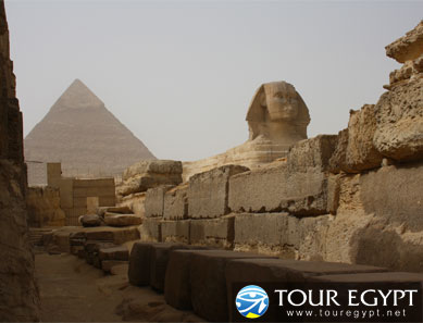
There are no more famous ancient sites within Egypt, or for that matter elsewhere in the world, than the Great Pyramids at Giza. They are, without question, the icon most associated with the Egypt. They have been both the main destination for tourists, and a source of imaginative thought to the world for over three thousand years.


However, there are actually over 100 pyramids in Egypt, many of which are relatively unknown to anyone who is not an ancient Egypt enthusiast. All but a very few are grouped around and near the City of Cairo, just south of the Nile Delta. Otherwise, only one royal pyramid is known in southern Egypt (at Abydos), that being the one built by Ahmose, founder of the 18th Dynasty and Egypt's New Kingdom.It may have also been the last royal pyramid built in Egypt.


Hence, major pyramids were not built throughout Egypt's ancient history. The Pyramid Age began with a burst of building, starting with the 3rd Dynasty reign of Djoser. Some of the early kings, most specifically Snefru, built more than one pyramid. Almost all of the kings added to their number through the end of the Middle Kingdom, with the possible exception of the First Intermediate Period between the Old and Middle Kingdoms. After the first Pharaoh of Egypt's New Kingdom, Ahmose, royal pyramid building by Egyptians ceased entirely. Somewhat abruptly the kings of the New Kingdom chose, rather than making their tombs completely obvious, to hide them in the hills of the West Bank of Thebes (modern Luxor).


However, smaller pyramids were constructed, for example in the Deir el-Medina necropolis, by private individuals. The Late Period Nubians who ruled Egypt also built relatively small pyramids with much steeper sides, though these were in fact constructed in Nubia itself. This tradition was carried on in Nubia after these southern rulers lost control of Egypt, and eventually, more pyramids were actually built in Nubia than Egypt, though on a much smaller scale.


Other pyramids in the world certainly exist, but their purpose, for the most part, was different than those of ancient Egypt. The most famous outside Egypt are probably those located in Mexico and to the south of Mexico, but these appear to have been built more as temples. In Egypt, all but a select few of the pyramids were built as tombs, sometimes to hold the physical body of a pharaoh (as well as other individuals), or to hold the soul of the deceased (as in the case of the small cult pyramids built next to the larger ones). Otherwise, the purpose of only a few small, regional stepped pyramids remains elusive.


While pyramids were, for the most part, tombs for the Pharaohs of Egypt, one must nevertheless question the reason that Egyptian rulers chose this particular shape, and for that matter, why they built them so large. Today, we believe that they chose the shape in order to mimic the Benben, a pyramid shaped stone found in the earliest of temples, which itself is thought to symbolize the primeval mound from which the Egyptians believed life emerged. This also connected the pyramid to Re, the Sun God, as it was he, according to some of the ancient Egypt mythology, who rose from the primeval mound to create life.


As far the great size of many of the pyramids in Egypt, we can really only surmise that the Pharaohs were making a statement about their own power and perhaps, about the glory and strength of their country. However, it should also be remembered that many of the latter pyramids were not nearly as large as the Great Pyramids at Giza (and elsewhere).


Pyramids evolved. The first of them was not a perfectly formed pyramid. In fact, the first Pyramid we believe that was built in Egypt, that of Djoser, was not a true pyramid at all with smooth sides and a point at the top. Rather, its sides were stepped, and the top of the pyramid truncated with a flat surface (as best we know). As the Egyptian pyramids evolved, there were failures as well glorious failures until finally, they got it right with what was probably the first smooth sided true pyramid built at Meidum. In fact, pyramids continued to evolve throughout their history, perhaps not always in outward appearances, but in the way that they were built and in the theology surrounding their construction. For example, towards the latter part of Egypt's Pyramid Age, Osirian beliefs seem to have had more and more impact on the arrangement and layout of the subterranean chambers.


However, soon after the first pyramids were built, their form became somewhat standardized. Royal pyramid complexes included the main pyramid, a courtyard surrounding the main pyramid, a much smaller cult pyramid for the king's soul, a mortuary temple situated next to the main pyramid, an enclosure wall and a causeway that led down to a valley temple. Some pyramid complexes included subsidiary, smaller pyramids for family members, and most were surrounded by some sort of tombs for family members.


Our thinking on pyramids has evolved considerably over the years. Many of us who are a bit older were taught that the pyramids were built using Jewish slave labor, which is a fabrication of immense proportions. Most of the pyramids were built long before the Jews made their appearance historically and currently, many if not most scholars believe they were not built using slave labor at all (or perhaps a nominal number of slaves).


Otherwise, we can also dismiss offhand alternative theories related to aliens or some lost culture being responsible for pyramid building. There is just far too much evidence, including tools, drawings, evolutionary changes, and even worker villages that rule these farfetched ideas obsolete.


However, some mysteries remain, even in some of the best well known Pyramids. The most famous of them all, the Great Pyramid of Khufu, continues, year after year, to give up a few more secrets, and there doubtless remains much to learn from these Egyptian treasures. There may even be one or more pyramids yet to be discovered.